What to Record Before Sewer Relining Access on Your Property
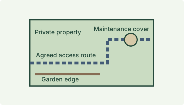
A water authority or contractor has advised that it may need to use your side path to reach a maintenance cover for sewer relining. The method is described as trenchless, but you still want a record of the garden edge, paving and gates before any personnel or equipment arrive. Ask the project contact to identify the surface route and the areas they expect to occupy before you arrange photographs. The useful starting point is a dated record of what can be seen and what the project contact has described, with any reinstatement terms kept in their own documents.
Confirm whether the project needs to use your property
Ask which access point the project proposes to use, how the team will reach it, and who is coordinating the arrangement. Melbourne Water describes trenchless relining in its published North Yarra Main Sewer rehabilitation project. The project information also discusses access tracks to maintenance holes. That is an example of why a project can work within the existing pipeline and still need some surface access. It does not establish that any equipment, temporary track or reinstatement will be required at your address. Check your notice and get the relevant contact to describe the intended route and scope.
If the notice includes a plan, ask which access, storage or laydown areas are proposed on your property and which are outside it. The route to a maintenance hole may be different from the route a resident normally follows to the garage. A report can identify both, if they overlap and it helps explain what is being recorded. Keep the latest plan and note which areas remain provisional. If a later revision changes the access route, a dated record of the original brief explains why photos were taken from one entrance and not another.
Know what the cover can tell you
Yarra Valley Water explains the differences between maintenance holes, inspection shafts and sewer easements. A visible cover can help locate the agreed work area and identify the surfaces that surround it. It does not establish the extent, condition or ownership of the buried system. If the authority’s asset record or project plan names an access point, keep that information available and reference it by date. Record the cover as it can safely be seen from outside. Leave it in place and ask the project team or responsible authority about opening or using it.
If there is a separate concern about an existing blockage, pipe defect or buried connection, state it clearly and ask which party is responsible for investigating the line. A visual condition record near underground drains and a specialist pipe inspection answer different questions. The pipe inspection may involve evidence that cannot be gathered by photographing the ground from above. If a resident recalls a prior overflow, note where and when it was reported. Keep that information separate from the accessible conditions the inspector can verify when visiting.
Make the surface baseline easy to follow
Start at the authorised entrance and work along the proposed route in sequence. Ask for a wide view of each change in surface before close views of items such as chipped pavers, existing cracks, gate catches or disturbed soil. Identify items by a durable landmark such as a threshold edge, fence post or building corner. Photograph any visible step or narrow section that matters to the brief while remaining within safe, permitted areas. If furniture or parked vehicles cover a part of the surface, let the record show what was obscured and whether access arrangements allow for an additional view.
Near the proposed work area, record visible ground cover, fixed features and ordinary use. For example, a garden bed can have a missing border block or mulch spread across part of an established path before any access occurs. A photograph may show this accurately when taken with a wide view of the surroundings. A close image by itself can be difficult to locate later if the path consists of repeating pavers. If more than one owner uses the route, our shared driveway baseline guide offers a way to distinguish common access areas from the parts controlled by an individual owner.
Document any temporary arrangement in its own place
Ask the project team whether it proposes mats, signs, a temporary access treatment or another arrangement that will alter what can be seen at the site. In some works the team may discuss whether a temporary bypass is needed to maintain sewer service. Treat that as project information and ask who will advise you about expected access, how long the arrangement is anticipated to stay and what to do if there is a problem. The condition record describes the areas accessible at the appointment. It does not approve the setup or assess the operation of the sewer.
A temporary drainage change at the surface can raise a separate question about existing ponding or old marks around an adjoining threshold. The temporary site drainage guide explains how to distinguish prior wet weather history from the dry-day observations, where those areas are in scope. If you are told a water-related change has already happened, note which information came from the project team and which conditions were directly seen. A clear note about timing is more useful than an assumption that every photograph depicts the original arrangement.
Keep access terms and condition evidence distinct
Ask for written confirmation of the agreed access arrangements and any areas the project team plans to reinstate. Keep that with the project notices. The condition report can show the visible surface before work and help locate each photographed item. Whether anything needs to be restored, who arranges it and how it is assessed depends on the relevant project arrangements and circumstances. The Building and Plumbing Commission describes a separate formal protection work framework where it applies. Ask the responsible contact whether that process is relevant to the works in question. A condition survey alone does not establish how property rights or access terms apply.
If the property contains a business, tenant or shared entrance, decide with the appropriate parties how to arrange entry and what personal information should be kept out of the frame. A visit agreed by one person may not cover every part of the property. An inspector can record the accessible route and the effect of any obstruction. Our limited access guidance explains why a report should state which views were unavailable. Where relevant, schedule a short return before the first work that would cover those views, and record the new date separately.
Plan the follow-up around what can be compared
Illustrative example. A project team proposes to reach a cover near a garden through a side gate. Before access, the record shows a worn gate latch, a small chip at a path corner and a discontinuity in the old garden edging. At the follow-up the path is clear but the edging is partly buried under new soil. A reviewer can locate and compare the visible features and note where the original view is obscured. The comparison does not determine the cause of a new defect or whether the contractor has met the exact reinstatement terms. That question needs the relevant agreement and other evidence.
Ask when access areas will be cleared enough for a practical revisit and what to do if you notice a change sooner. Keep any interim photos alongside the originals, with the actual date, photographer if known and location retained. Record any clean-up or repair before the revisit so the reviewer can understand the difference in appearance. Our after-work comparison guide covers matching viewpoint and recording new access constraints. If a defect presents an urgent hazard or there is a sewer service concern, contact the responsible service or project team promptly.
Arrange the record before surface access begins
For a Melbourne dilapidation inspection, send the address, current works notice, agreed access path and anticipated dates. Identify the relevant entrance, staging areas and fixed features you want recorded. If the team expects to take its own photos, ask what those cover and when you will get them. You can then decide whether the available record needs a supplemental visit to show an area that is outside their scope. Keep earlier maintenance photos and invoices identifiable by date and subject.
You can prepare a simple path schedule if access is complicated. List the first gate, narrowest section, maintenance cover and any exit that is expected to be used. Note which party confirmed each segment. If temporary access goes across different surfaces, flag what is already worn, recently repaired or difficult to see. Those details make it possible to explain which areas were included before work and why. Where a project changes the route, record the revised scope and distinguish any new photographs from the initial survey.
Flag spots that may look different after an ordinary change
A surface can change during a works period for reasons that need to be recorded separately. A garden border may be altered by the owner, or the installer may remove a latch after the occupant reports a problem. Note who observed the work, when it happened and what part of the baseline it affects. If you have already planned paving repairs during the same period, share those dates with the inspector. Otherwise a later reader may assume that a visible difference is related to the sewer access when there was another intervening activity.
When the route includes a section that is always damp or regularly hidden by a parked car, ask for a baseline from the available viewpoint and write down what cannot be compared. Weather conditions can change the appearance of paving and soil. A dark patch recorded on the return visit may not have been visible under dry conditions, even if the camera position is almost identical. The report can state the weather and lighting observations when known. Treat photographs from residents that show other conditions as separately sourced material with their own dates.
If a plan shows distinct exit and entry points, write the sequence in the scope so the inspector can document both routes without guessing how they will be used. A project team’s later change can then be matched to a dated variation or work notice. That gives the comparison a clearer reference than a single line describing the whole garden as an access area.
References
Ask ClearScope about your property
Send the address, proposed work, expected start date and any access arrangements you already have.
Request an inspection