Dilapidation Before Works Near a Council Street Tree
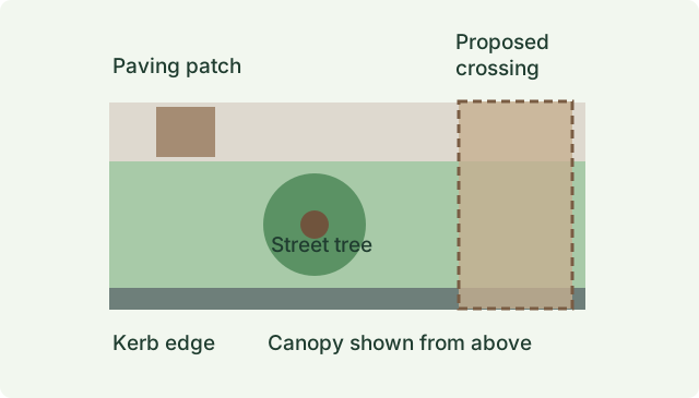
The builder is planning a new crossing or utility trench near a street tree, and you want a dated record before the frontage changes. Start with the whole frontage. Identify the trunk, adjoining paving, verge, kerb and the part of the work shown closest to the tree. A street tree baseline records visible condition and identifies what needs the council or an arborist to assess. Ask who manages the tree and what the approved plans say about work near it. A well-framed photograph can help show a broken limb or an old paving patch, but it cannot establish the condition of roots or authorise work near them.
Establish which tree and which frontage are in scope
Ask for the address, the side of the street and the relevant drawing. If there are several trees, identify each using stable landmarks such as a property corner, a pole number or the existing crossover. Use labels that can be carried into the follow-up report. A label like Tree A is useful only if the plan and the photographs identify which tree it means. Avoid assuming that a tree is privately owned because the trunk appears close to a fence. If the boundary or management responsibility is unclear, ask the council or the appropriate land manager and keep the question open in the record.
Read the drawing with the responsible builder or designer. Ask where vehicles will approach, what may be removed and where services are intended to pass. If the crossing or services alignment changes, note which version was used to arrange the visit. Ask whether the council has requested a tree protection plan or identified any specific constraints. Use the limits on the drawing as references for the observation, and leave the interpretation of any protection zone to the council and arborist. The retained tree planning guide is a useful companion when the design question is the location of a building footprint around a tree on the lot.
Capture visible tree features without a tree diagnosis
Take a wide view showing the tree and frontage together, then record features visible from the agreed safe position. For example, the trunk may show an old scar, a limb may already be missing, or there may be pruning cuts visible below the canopy. Include enough of the trunk or canopy in each frame to locate the feature. A closer view can record its visible shape. Photographing these details does not require an inspector to remove bark, disturb soil or enter a restricted road area. If parked vehicles, fencing or foliage block a view, say so and note which other view is available.
Keep language observational. A line across the bark can be described by its location and appearance. Its age, cause and significance are questions for someone with the appropriate expertise and supporting evidence. Different light, season and camera angle can change how the canopy looks. Include the date and photograph from more than one useful point where it is safe and permitted. If there is a concern about a damaged branch or the safety of the tree, contact the responsible authority. The baseline should remain a record of visible features and any information supplied, with the authority’s or arborist’s advice recorded separately.
Record the verge, paving and fixed reference points
Around the tree, look for surfaces that can later be compared from the same location. Note visible depressions, bare soil, damaged grass, patched concrete, openings between paving slabs and changes in level at obvious edges. Include fixed reference points such as a drain grate, kerb joint or the beginning of the existing crossing. Record obvious surface changes in context, and identify which ones are next to the area the drawings show will be disturbed. Paving lifted near a tree and visible roots in the verge can both be described without saying that one caused the other. The vehicle crossing and kerb guide covers the broader hardscape baseline when demolition traffic is part of the proposal.
If the project affects both the verge and a neighbour’s frontage, plan how to record both areas without mixing up public and private assets. For a fence that meets the verge, identify which side can be observed and whether the owner permits additional photographs. If stormwater or other services are involved, note visible lids and covers while leaving buried locations and condition to the service information and relevant specialists. Our guide to visible records near buried drainage explains why a cover location should be recorded separately from any assumption about the pipe beneath it.
Check council and arborist requirements before arranging the visit
The City of Melbourne’s developer and builder fact sheet describes a tree protection and management plan for certain work around council trees, with photographs and a record of observable pre-existing damage. Boroondara’s construction tree protection guidance describes its own local process. These sources are useful examples of why the council’s requirements should be confirmed for the address. Ask who is responsible for any specialist documentation and whether an arborist must supply it. Confirm whether the council wants particular photographs, an inspection by its staff or a record at more than one stage. A general building condition report can help document the frontage where agreed, with the formal tree assessment supplied by the nominated professional where required.
If the builder has received protection work directions, ask the relevant building surveyor how the public frontage fits with the rest of the condition survey. The Building and Plumbing Commission explains the surveyor’s role in determining whether statutory protection work is required and describes the adjoining property condition survey for that process. That guidance helps identify who should clarify the scope. It does not establish whether a particular street tree is subject to a permit condition. For broader issues involving a public work zone or several properties, the roadworks and civil excavation guide explains how to organise comparable observations along a larger frontage.
Keep the dates clear before and after works
Arrange the first visit before temporary covers, fencing, equipment or material storage obscure the ground around the tree. If part of the work has begun, write down exactly what stage was visible and request any dated photographs taken beforehand. Mark who supplied them and what areas they show. A rear view of the tree can still help when its street face is obstructed, as long as the report records that the views differ. If dates change or council staff need the area undisturbed for their own visit, keep the baseline and the revised programme together so people can see what was recorded at each point.
Agree who will say when the frontage can be rechecked. A useful comparison may be possible after temporary fencing has been cleared, before new landscaping or surface repairs erase the features in question. Match the tree identifier, side of street, kerb joint and viewing direction. Record any pruning, reinstatement, weather event or other work already known, with its source and date. Where photos show fresh surface disturbance or a change in canopy appearance, record where and when it was observed and refer the question to the appropriate person. The comparison inspection guide explains how to report differences when the original view cannot be repeated.
An illustrative frontage with a patched path
Imagine a home extension with a proposed replacement crossing near a council tree. Before the contractor arrives, a wide photo shows a patched section of footpath next to the trunk and a narrow strip of bare soil on the opposite side. A second photo shows a bark mark facing the road. The drawing identifies where the crossing is proposed. The inspector notes these details and the date, while the owner asks council who should assess the tree and which parts of the drawing matter for that review.
After the crossing work, the owner sees a different patch of bare soil. Matching the earlier views shows where the old bare strip was and which area is newly visible. It may also show where construction fencing stood. The report can describe what the photographs establish, what appeared different on the day and what remains uncertain. It cannot establish which activity exposed soil or the condition of any roots. If the bark mark cannot be viewed from the same point without standing in the road, arrange safe access through the responsible party or retain that limitation.
What to send when asking about a report
Send the site address, an annotated photograph or plan locating the tree, the current crossing or trench proposal and the expected first work date. Mention any council requirement already received, who is arranging the arborist’s assessment and which areas will be safe to view. Include other frontage features you want recorded and explain if any are on neighbouring property. The Melbourne dilapidation inspection service can discuss the visible building and frontage record alongside the other documentation. Ask for the agreed scope in writing, including when it would be useful to repeat the observations and who should receive a copy of the report.
If the documents refer to multiple frontage activities, ask for their dates separately. An early services contractor might visit before the builder removes the crossing, and temporary deliveries may be made from a different position than shown on the final drawing. Keep the contact who manages the crossing or service works with the report distribution details. This makes it easier to share a relevant record without circulating images of other properties unnecessarily.
Consider how the report will describe an area that is scheduled to change. A planned removal of a slab needs a record of the visible paving immediately alongside it, including any joint or patch that can later be identified. If reinstatement is expected, note the part of the frontage that will be replaced and the part that should remain visible for comparison. Ask whether the council wants a separate completion record after the verge or crossing has been reinstated. Photos from that visit can show the new surface, while the pre-work record remains the reference for what was there at the start.
If you plan to circulate the record, choose photographs that show the relevant physical features without including faces, vehicle registrations or unrelated private areas where practical. Store the original images with their dates. Where a resident has provided an earlier photograph, identify it in the report so that a later reader can see which observations were made during the inspection.
References
Ask ClearScope about your property
Send the address, proposed work, expected start date and any access arrangements you already have.
Request an inspection